
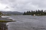
A boat launch parking lot in Oregon's Tillamook County, entirely under water. The photo was taken at the peak of a king tide on Nov. 6, 2021.
Tyler Sloan / Oregon King Tides Project
The Oregon Coast is set to experience higher-than-normal tides this weekend, and researchers are asking Oregonians to take photos to help document sea-level rise as climate change worsens.
From Friday through Sunday, the Oregon Coast will be experiencing some of the highest tides of winter, known as king tides. King tides occur when the moon, earth and the sun align at the closest points to each other, leading to enough gravitational pull to create larger-than-usual tides.
The Oregon King Tides Project is asking anyone with a camera to safely take and share pictures of the king tides, which can add about 3 feet to average tides. The resulting photo collection will help document and inform researchers on the impacts of sea-level rise, flooding, and erosion — all of which are becoming worse as global warming continues to play out.
The continued burning of fossil fuels is creating greenhouse gas emissions that are contributing to climate change. Those greenhouse gases are trapped in the atmosphere, raising average temperatures and in turn, melting glaciers and ice sheets around the world. That is adding more water to the ocean and increasing sea levels. The Pacific Island nations are already experiencing significant damage from sea-level rise.
Related: Oregon coastal towns confront a fate tied to Antarctica's melting glaciers
The Oregon Coastal Management Program is one of two organizations involved with the Oregon King Tides Project. Coastal Shores Specialist Meg Reed said documenting king tides now gives us a glimpse of what we can expect for the future as climate change worsens and be better prepared.
“They can have big impacts on communities,” she said. “They can create erosion, flooding, have impacts to the natural infrastructure as well as human infrastructure and it’s important to look at those impacts and see how we can start adapting as a community to sea-level rise.”
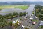
Nehalem, Oregon, flooded after a king tides event on Nov. 6, 2021.
Tyler Sloan / Oregon King Tides Project
She said king tides create the highest of high tides and the lowest of low tides, and they are predictable—which makes it a perfect opportunity to learn more about sea-level rise in our region.
“With sea-level rise, we just expect the same hazards that we already experience on the coast to get worse,” Reed said. “So potentially those flooding and erosion events that we already experience will maybe become more frequent will happen more often in the winter or they might become more extreme.”
Reed said some areas of concern are places like Rockaway Beach which experiences lots of flooding during a king tide event, as well as downtown Nehalem. Other areas include oceanfront properties and even areas like airports and railroads that are low-lying are areas of concern.
Right now, the Oregon Coastal Management Program is currently working on a sea-level rise planning guide for coastal cities to begin to think about how cities, residents and businesses can begin to adapt to sea-level rise and move those projects forward.
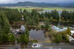
Vehicles were wading to get through the intersection of Highway 101 and 7th Street. Taken at the peak of a king tide on Nov. 6, 2021.
Tyler Sloan / Oregon King Tides Project
Short-term options include putting up structural measures like seawalls or riprap. Other options include preventing certain types of development from being built in hazardous areas and proactively removing structures that are on the coastline if possible.
The Oregon King Tides Project photo account currently has more than 3,000 images. Residents can submit their photos on the Oregon King Tides Project website. The project is a collaboration between the Department of Land Conservation and Development’s Oregon Coastal Management Program and the Oregon Shores Conservation Coalition.