Fire crews are protecting structures from the McKinney Fire in a large rural area of Northern California’s Siskiyou County, west of Interstate 5. The fire, which started after several days of intense lightning storms, has prompted evacuations in areas of Yreka west of I-5. The fire showed little progress towards Yreka on Sunday, according to officials.
Evacuation orders spanned a variety of unincorporated communities along Highway 96, including Klamath River, Hamburg and Seiad Valley. Evacuation orders for Siskiyou County can be found here.
A temporary evacuation shelter has been set up at the Weed Community Center at 161 E Lincoln Ave.
New lightning fires were still being detected on Sunday with crews responding to two other fires in the area. The 15-acre Kelsey Creek Fire prompted mandatory evacuations southwest of the McKinney Fire. The China 2 Fire is burning about two miles west of Seiad Valley.
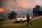
A man runs to a truck as a wildfire called the McKinney fire burns in Klamath National Forest, Calif., on Saturday, July 30, 2022.
Noah Berger / AP
The region remains in a red flag warning on Sunday with the threat of dry lightning and strong wind. “These conditions can be extremely dangerous for firefighters, as winds can be erratic and extremely strong, causing fire to spread in any direction,” according to the McKinney Fire description on Inciweb.
Persistent drought conditions have caused extremely dry fuels and resulted in rapid fire spread.
In addition to Cal Fire, the Oregon State Fire Marshal’s office announced on Sunday that they were mobilizing structural task forces to assist with the McKinney Fire. The task forces of firefighters, engines and water tenders are expected to arrive in California on Sunday afternoon.
A red flag warning will remain in place in the Yreka area through Sunday night. The National Weather Service has a fire weather watch in place through Monday night.
The Pacific Crest Trail Association and Forest Service announced the closure of a 110-mile section of the popular hiking trail on Saturday, urging hikers in the area to evacuate to the nearest town. The closure stretches from Etna Summit to Mt. Ashland, across the Oregon border.
Smoke from the McKinney Fire, which is burning approximately 10 miles from the Oregon border, produced poor air quality in the Rogue Valley. The air quality index was listed as “unhealthy” for Ashland on Sunday and “unhealthy for sensitive groups” in Medford.