Travelers on Oregon's mountain passes should prepare for the worst Tuesday and Wednesday with a blizzard warning in effect as a storm rolls in with high winds and heavy snow.
Anna Reed / Statesman Journal
The Pacific Northwest’s weather is taking an icy turn this week that spells trouble for mountain travelers the next couple of days and could even bring snow to lower elevations.
A blizzard warning is in effect through Wednesday with high winds and heavy snow forecasted in the Cascades of Oregon and Washington and Eastern Oregon’s Blue Mountains.
The National Weather Service says mountain passes will see whiteout travel conditions, with wind gusts up to 55 mph.
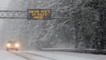
Travel over the mountains is recommended for emergencies only through Wednesday afternoon. If travel is a must, the Oregon Department of Transportation says drivers should expect to encounter chain restrictions and plan extra time for the journey. Delays and closures are common during storms of this magnitude.
Higher elevations could see several feet of snow. That’s good news for ski resorts in need of more snowpack, but the snow also comes with wind gusts up to 75 mph. Both Timberline and Mt. Hood Meadows closed Tuesday because of the conditions.
High wind and winter weather advisories are also in place for much of the rest of the state through Wednesday. Snow is expected in areas above 1,500 feet in elevation.
Blizzard warning? Expect:
— OregonDOT (@OregonDOT) January 9, 2024
❄️ Sustained winds or frequent gusts of 35 mph+
❄️ Heavy or blowing snow that reduces visibility to less than a 1/4 mile
❄️ Extreme conditions lasting three hrs.+
Safest blizzard travel strategy? Stay home so crews can tackle winter's wrath. #TripCheck pic.twitter.com/ECxke3Awzn
“Last night I-84 in eastern Oregon saw multiple closures for crashes and spun-out vehicles that struggled to gain traction on snowy roads,” ODOT officials stated in a press release.
ODOT also reported that U.S. 97 is snow-covered from Redmond south to the border with California and blizzard conditions are due to hit the corridor south of Bend.
A light dusting to as much as a couple of inches of snow was possible in lowland areas of Portland Metro and Southwest Washington from Tuesday night through Wednesday morning, according to the National Weather Service.
Snow tonight? For Portland metro and southwest Washington, the latest forecast snow totals range from a dusting to a couple inches. Plan for some extra morning commute time, and monitor local sources for any school impacts. #orwx #wawx #pdxtst pic.twitter.com/Ff8N4x8xec
— NWS Portland (@NWSPortland) January 9, 2024
After the blizzard rolls through the region, another winter weather system is expected to move in later this week.
That one could bring snow to lower elevations in the Willamette Valley by Saturday morning, although the National Weather Service said forecast models varied widely as of Tuesday, with some predicting rain in the Portland area and others predicting up to 6 inches of snow.