
Heavy snow and gusty winds are expected along Cascade passes in Southwest Washington and most of Oregon for the next few days.
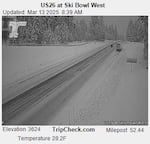
In this image captured by an Oregon Dept. of Transportation camera just after 8:30 a.m. on March 13, snow has fallen along U.S. 26. near Ski Bowl
Oregon Dept. of Transportation
The National Weather Service has issued a winter storm watch through Saturday afternoon. Up to 2 feet of snow could accumulate by then, mostly at elevations above 2,500 feet. Wind gusts could reach 35 miles per hour.
Several inches of snow fell in the passes overnight Wednesday into Thursday morning.
“So if you are venturing across the Cascades over the next 3-4 days, be prepared for hazardous winter weather conditions,” the National Weather Service area forecast discussion read Thursday morning. “Winter isn’t done with us yet.”
❄️You can tell from the traffic cameras this morning winter isn't done with us quite yet. If you're traveling over the Cascade passes through the weekend, be prepared for winter-like driving conditions! #ORWX #WAWX pic.twitter.com/BJ75xQtWMz
— NWS Portland (@NWSPortland) March 13, 2025
Forecasters said another weather system could bring more snow to the passes Saturday through Monday.
During this period of winter weather, backcountry recreation along the Cascades is not advised.
At lower elevations, widespread rain is expected to continue through at least early next week. Breezy to gusty winds, and even isolated thunderstorms, are also possible.
The National Weather Service forecast as of Thursday morning showed the heavy rain transitioning to showers and sun breaks on Tuesday.